The Capitan Grande Canyon
Most of the original road through the reservation is now covered by the waters of El Capitan Lake, and the uniqueness of the canyon is all but forgotten, but Ellen Head has described her recollections of the reservation as it was in the early 1930’s.
The road ran alongside the San Diego River from the foot of Eagle Peak Grade to Chocolate (chock-uh-lah-tee) Creek and on into Lakeside. The canyon was narrow at its start, but broadened to wider fields as it went south. Cedar, Boulder, Tule Springs, and Los Conejos Creeks fed into the river on its way through the reservation. There were no bridges spanning the creeks because, except in very wet weather, the crossings were shallow enough for buggies and horses to ford easily. It was a quiet pleasant ride. Trees grew in close stands along the creeks and river, creating shady and cool stopping places.
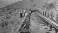
The village (or Rancheria) where most of the people lived was near Boulder Creek with oaks and sycamores lining the road. Farther on was the diverting dam that directed river water into the wooden flume that wound around the hills on the east side of the valley. Across the road from the dam was the flume walker’s house.
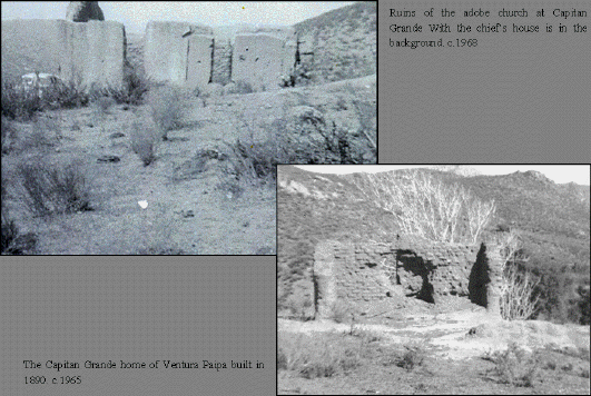
West of the river the Ventures had an adobe house on the side of the hill, and beyond that was the Tribal Chief’s house. Back on the east side of the river was the adobe church, the school house and the fiesta (powwow) grounds in a grove of oaks. During the lively fiestas, which seemed to last for days, there was much dancing and excitement, a large bonfire lighting the area for celebrating far into the nights.
At South Fork another creek fed into the river, and there was a sort of logging trail where at some time earlier timber from higher elevations had been hauled down to the road.
The Paipa’s house was an adobe. They caught and sold wild horses and pastured them in a field across the road from the house. The herd was a beautiful sight to see when they took off running, their manes and tails flying in the wind. (Ellen’s brother Ernie bought a Paipa horse for five dollars and had years of boyhood adventures with him).
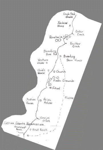
East Fork, where the Los Conejos flowed in, was not far from the reservation’s south boundary. The Henderson and Head ranches bordered that line.
At the Chocolate, the flume water was piped under the creek and then, on the other side, flowed into the next section of the flume to continue its journey to San Diego.
Article
Excerpts from Joe Head’s Account of his Early Life at Capitan Grande
“Jonathan Perkins, a man from over in Flinn Valley, was interested in getting a school started. In talking with my father I got the idea that the school had something to do with a well. I understood that I could go (to school) but I would have to be big enough to reach the well rope. Finally the school was organized and was named El Capitan. This is the only schooling I had and I did not complete the sixth grade.” (Note: Ellen Head remembers Dad telling her that his father, Arthur F. Head, and Jonathon Perkins built the road out of Chocolate Canyon southward up the steep hill so that the children of the valley could get to school. They either walked or rode horses. That road is there today but has been gated and locked for years).
“RAMON AMES – I knew him better than anyone else. As boys we played together and fought each other, and later he worked for my father for several years and lived with us as one of the family. He always wanted an education, and he attended El Capitan School in Flinn Valley whenever he could. He finally went to Riverside, California to attend the Indian school named Sherman Institute. In 1910 he came back to Capitan Grande and farmed there until the City of San Diego started to build El Capitan Dam. He was moved to Barona along with about thirty others. He worked for the Indian Police Department for several years until he died in 1957.”